Last updated: August 2026
Introduction:
Kevin Lynch, an American urban planner and author, introduced a groundbreaking perspective on urban design in his 1960 book The Image of the City. His research focused on how people perceive and mentally map urban environments, emphasizing the importance of visual clarity in cities. More than six decades later, Lynch's framework remains one of the most widely taught tools in architecture and urban design education — and in 2026, it continues to shape how planners and students read cities from Mumbai to Manhattan.
According to Lynch, a city’s legibility—the ease with which its spatial structure can be understood and navigated—plays a crucial role in shaping people’s experiences.
To explain this, Lynch identified five key elements that help people understand and remember a city:
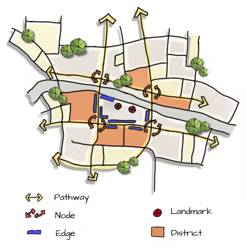
Image Credit: Shivani Chougula @Kaarwan
- Paths – The routes people use to move through a city.
- Edges – Boundaries that define and separate different areas.
- Districts – Large sections of a city with a distinct character.
- Nodes – Strategic points of interaction and activity.
- Landmarks – Iconic reference points that aid orientation.
These elements help in structuring urban spaces, making cities more navigable, cohesive, and memorable. Now, let’s explore each element in detail and its significance in urban design.
1. Paths: The Movement Network of a City
Definition: Paths are the streets, sidewalks, transit routes, and other movement corridors that people use to travel through a city. They are the most dominant element in how people experience urban spaces since movement defines perception.
Paths are the dominant element through which people experience cities because movement shapes perception more than any static feature. Lynch observed that people with strong mental maps of a city typically organised them around key paths first. Streets with consistent character — active frontages, clear visual cues, and human-scale design are far more legible and memorable than anonymous corridors. In urban design practice, well-planned paths are the foundation of any successful city layout because they determine how intuitively people can move through and understand the urban environment around them.
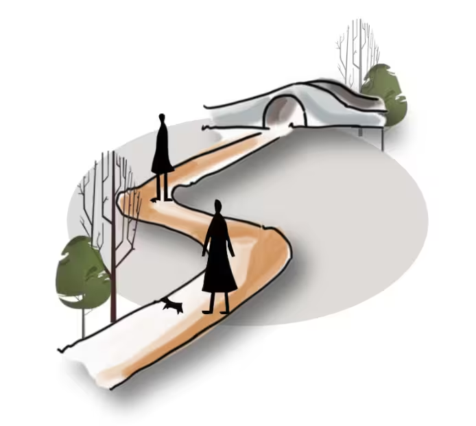
Paths: The Movement Network of a City
Image Credit: Shivani Chougula @Kaarwan
Architectural & Urban Significance: Paths shape how people navigate and mentally map a city. A well-designed street network improves accessibility, connectivity, and urban efficiency. Pedestrian-friendly streets, well-planned public transport routes, and bike lanes contribute to a livable and organized urban environment.
Examples:
- Champs-Élysées, Paris – A grand boulevard known for its vibrant urban experience.
- Manhattan Grid, New York – A structured street layout improving movement and orientation.
- Mumbai Local Train Network – A crucial path for daily commuting, defining the city's movement pattern.
Understanding how movement networks shape spatial perception is also a core skill in site analysis — the process architects use to read and interpret a location before beginning any design work.
A well-planned path system ensures a smooth flow of traffic while enhancing pedestrian accessibility and experience.
2. Edges: The Boundaries That Define Urban Space
Definition: Edges are physical or visual boundaries that separate one part of the city from another. They can be natural (rivers, shorelines) or man-made (walls, highways, railway lines).
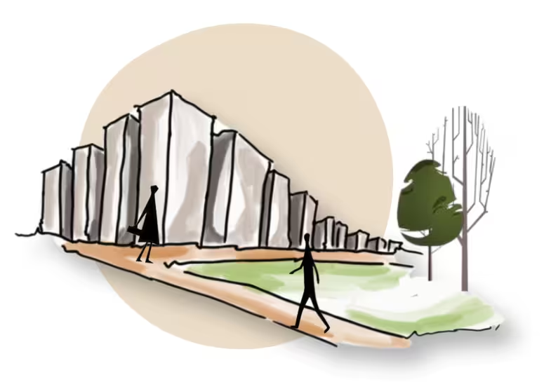
Image Credit: Shivani Chougula @Kaarwan
Architectural & Urban Significance: Edges help in structuring urban space by marking clear distinctions between different areas. They can either act as barriers (restricting movement) or as transitions (gradually connecting spaces). Strong edges contribute to a well-defined cityscape, enhancing both functionality and aesthetics.
Examples:
- The River Thames, London – A natural edge dividing north and south London.
- Berlin Wall (historical) – A political and physical edge that shaped urban identity.
- Elevated Expressways in Mumbai – Acting as barriers but also defining city zones.
Unlike paths, which invite movement through them, edges are perceived from the side — they define where one area ends and another begins. Lynch distinguished between barrier edges that block movement entirely and seam edges that allow some permeability between areas. The most successful urban edges are those that function as seams — creating clear definition without creating division. When edges are designed thoughtfully, they strengthen city legibility by making district boundaries easy to recognise and mentally map
Cities should focus on making edges more permeable by integrating green corridors, pedestrian bridges, or waterfront promenades, transforming them from barriers into connectors.
3. Districts: The Character Zones of a City
Definition: Districts are large urban areas with a distinct identity, based on architectural style, land use, or cultural significance. They are recognizable and provide a sense of belonging.
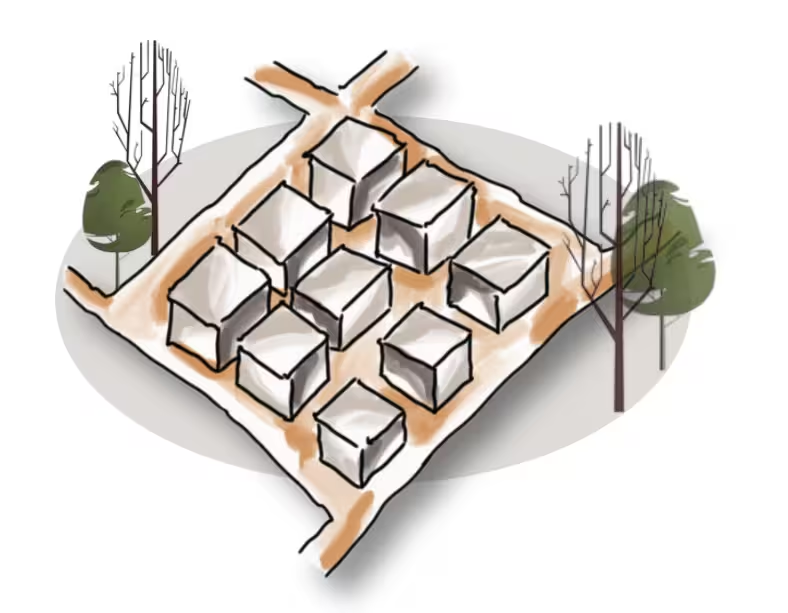
Image Credit: Shivani Chougula @Kaarwan
Architectural & Urban Significance: Districts create diversity in the urban fabric, giving each area a unique function and atmosphere. They influence urban planning by determining land use patterns and guiding zoning regulations. A well-designed district enhances social interaction and local identity.
Examples:
- Times Square, New York – A commercial and entertainment district with a vibrant identity.
- Lutyens’ Delhi, India – A government district defined by its colonial architectural style.
- Bandra, Mumbai – A blend of historic and modern identity, shaping urban lifestyles.
Districts function at a larger scale than the other four elements, they are regions you enter into rather than points you pass through or boundaries you cross. Lynch noted that districts have both an interior character that defines them and an outer boundary that contains them, which often overlaps with edges. Strong districts give residents and visitors a sense of place identity — the feeling of being somewhere specific, not anywhere generic. In urban planning, well-defined districts guide zoning decisions, land use patterns, and neighbourhood character strategies.
Mixed-use districts, cultural quarters, and business hubs play a key role in fostering a dynamic and livable urban environment.
4. Nodes: The City’s Activity Hubs
Definition: Nodes are strategic points in a city where major paths intersect, creating centers of activity. These can be transport junctions, plazas, or major commercial areas.
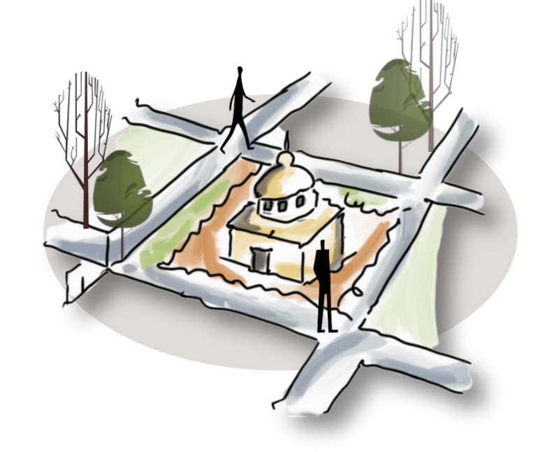
Image Credit: Shivani Chougula @Kaarwan
Architectural & Urban Significance: Nodes serve as gathering points, making them crucial for urban vibrancy. A well-designed node enhances connectivity, public interaction, and economic activity. They also improve walkability and social engagement in urban spaces.
Examples:
- Shibuya Crossing, Tokyo – A dynamic pedestrian node that defines city life.
- Connaught Place, Delhi – A commercial and transport hub serving as a central node. Nodes are particularly significant in architectural site analysis and urban design studies, where identifying activity concentration points helps designers understand how people actually use and move through space.
- Chhatrapati Shivaji Maharaj Terminus, Mumbai – A transport node shaping commuter movement.
Nodes can be small — a street corner where people habitually gather or large, like a major transit interchange serving thousands daily. What makes a node a node in Lynch's framework is not size but strategic concentration: they are points where paths converge and activity intensifies. Lynch also distinguished between junction nodes, where paths cross and create natural gathering points, and concentration nodes, which are thematic centres like a market square, civic plaza, or commercial hub. Understanding nodes is essential in urban design because well-designed nodes improve walkability, social engagement, and the overall legibility of a city.
Urban planners should design nodes as functional yet aesthetically engaging spaces with easy pedestrian movement and multi-modal transport integration.
BIM teaches you to design large and small-scale projects with ease and efficiency.
5. Landmarks: The Icons of a City
Definition: Landmarks are visually prominent structures or natural features that help people orient themselves in a city. They act as reference points for navigation and contribute to the city’s identity.

Image Credit: Shivani Chougula @Kaarwan
Architectural & Urban Significance: Landmarks make cities memorable and enhance cultural and historical recognition. They can be iconic skyscrapers, monuments, natural formations, or significant public buildings. Their visibility and uniqueness help in reinforcing a city’s image.
Examples:
- Eiffel Tower, Paris – A global landmark defining the city’s skyline.
- Gateway of India, Mumbai – A historical and symbolic landmark.
- Charminar, Hyderabad – A cultural and spatial landmark aiding navigation.
Lynch distinguished between local landmarks — reference points visible only within specific neighbourhoods and regional landmarks visible across the entire city. Effective landmarks do not need to be ancient or monumental. A distinctively painted building, an unusual tree, or a brightly lit sign can serve as a landmark if it is visually unique and consistently recognisable from its surroundings. The key quality Lynch identified is singularity a landmark must stand out clearly from its context to function as a reliable reference point for navigation and mental mapping.
Landmarks should be carefully placed in urban layouts to serve as focal points, aiding wayfinding and adding to the aesthetic appeal of cities.
Urban Legibility and Imageability: The Core of Lynch's Framework
Beyond the five elements themselves, Lynch introduced two connected concepts that bring the entire framework together and explain why some cities feel intuitive to navigate while others feel confusing.
Legibility refers to how easily the physical environment can be understood and mentally organised. A legible city is one where paths, edges, districts, nodes, and landmarks work together coherently allowing people to form accurate mental maps without confusion or disorientation. Lynch argued that legibility is not a luxury in urban design — it directly affects how safe, confident, and comfortable people feel in urban space.
Imageability is the quality of a physical object or environment that makes it likely to evoke a vivid, clear, and strong image in the mind of any observer. Lynch argued that high imageability has practical consequences beyond aesthetics a city with strong imageability is one where residents and visitors alike can navigate intuitively, form emotional connections with place, and develop a genuine sense of belonging.
Together, legibility and imageability form the philosophical foundation of Lynch's argument: that good urban design is not simply functional or beautiful it is readable. A city that can be read clearly by its inhabitants is a city that works for them on every level — practical, emotional, and social.
Lynch analysis diagrams — visual maps that identify paths, edges, districts, nodes, and landmarks in a real urban area are one of the most commonly used tools in architecture school projects and professional urban design practice.
How to Draw a Lynch Analysis Diagram
A Lynch analysis diagram is a visual map of an urban area that identifies and marks its paths, edges, districts, nodes, and landmarks. It is one of the most commonly assigned exercises in architecture schools and urban design studios, used to assess the legibility and imageability of a real city or neighbourhood.
Step 1 — Choose your study area
Select a defined urban area — a neighbourhood, a city centre, or a campus. Set clear boundaries for your analysis area so your diagram has a defined scope. Common choices for Indian architecture students include a market district, a heritage zone, or the area around a major transit hub.
Step 2 — Base map
Start with a simple base map of your chosen area — either hand-drawn or printed from an online map. This is the blank canvas on which you will overlay the five Lynch elements.
Step 3 — Walk the area
Move through the area — physically or virtually — and observe it through the lens of Lynch's five elements. Ask yourself: Where are the main movement corridors (paths)? Where are the clear physical boundaries (edges)? Which zones have a distinct character (districts)? Where do people gather or paths intersect (nodes)? What visual reference points are visible from a distance (landmarks)?
Step 4 — Map each element with a distinct symbol or colour
Use a consistent visual language for your diagram:
- Paths → thick lines following the movement routes
- Edges → bold boundary lines, often with a hatching or double-line treatment
- Districts → coloured zones or shaded regions
- Nodes → circles or dots at intersection points
- Landmarks → star or triangle symbols at distinctive points
Step 5 — Annotate and analyse
Add brief notes explaining your choices. Why is this road a primary path and not just a secondary route? Why does this waterfront function as a barrier edge rather than a seam edge? Your annotations transform the diagram from a map into an analysis.
Step 6 — Assess legibility
Look at your completed diagram and ask: does the area have a clear, readable structure? Are the five elements working together to create a coherent urban image, or are there conflicts and gaps? Your conclusion should summarise the legibility and imageability of your chosen area.
For students preparing for GATE Architecture 2026, Lynch analysis diagrams are a recurring component of the exam's urban design section. Explore Kaarwan's GATE Architecture Crash Course to build your urban design analysis skills alongside other core exam topics
Source: Kevin Lynch — The Image of the City (1960)
The five urban elements — paths, edges, districts, nodes, and landmarks — were introduced by Kevin Lynch in his landmark 1960 publication, The Image of the City, published by MIT Press. The book was based on research conducted in three American cities: Boston, Jersey City, and Los Angeles.
Standard academic citation format:
Lynch, K. (1960). The Image of the City. MIT Press.
The book introduced the concepts of legibility and imageability that remain central to urban design theory and practice today. Lynch's framework is widely referenced in architecture and urban design literature and remains a standard component of B.Arch, M.Arch, and urban planning curricula globally.
Architecture and urban design students who want to apply Lynch's framework in live project contexts can build this skill through Kaarwan's site analysis and architectural design workshops.
Conclusion:
Kevin Lynch's five urban elements — paths, edges, districts, nodes, and landmarks — remain, even in 2026, one of the most widely applied frameworks in urban design and city planning worldwide. Together with his concepts of legibility and imageability, they provide a complete language for understanding how people experience, navigate, and emotionally connect with cities.
These elements do not operate in isolation. Paths penetrate districts, edges define them, nodes activate intersections, and landmarks punctuate the skyline creating a layered, interdependent urban image that either works for its inhabitants or against them. A well-planned city integrates all five elements effectively, ensuring a balance between functionality, accessibility, and a strong sense of place.
Urban designers, architects, and planners use Lynch's framework as a foundational analytical tool from conducting Lynch analysis diagrams for student projects to informing large-scale master planning decisions. Whether you are analysing an existing city or designing a new urban environment, these five elements provide a consistent, evidence-based starting point for reading and shaping urban space.
Understanding Lynch's framework is one thing applying it professionally is another. If you want to develop your skills in site analysis, urban legibility assessment, and architectural design thinking, explore Kaarwan's architecture and urban design courses, built for students and professionals who want to move from theory to practice.
These were some interesting facts about Kevin Lynch's five Urban Elements. Stay tuned for more information on other significant topics in the AEC industry and follow Kaarwan for such detailed guides!
FAQs
1. What are Kevin Lynch’s 5 elements of urban design?
Kevin Lynch identified Paths, Edges, Districts, Nodes, and Landmarks as the five foundational elements people use to form mental maps of cities.
2. Why are 'paths' crucial in urban design?
Paths are the primary channels—like streets, sidewalks, and railways—that guide movement and shape how people navigate and experience a city.
3. How do 'edges' influence city legibility?
Edges are boundaries—physical (e.g., rivers, highways) or perceptual (e.g., shifts in architecture)—that define districts and help people mentally structure the urban environment.
4. What role do 'districts' play in urban perception?
Districts are medium-to-large areas with consistent character (architecture, usage, atmosphere) that help people orient themselves and recognise different city zones.
5. What makes a 'node' significant in a city?
Nodes are focal points—junctions, plazas, transit hubs—that act as centres of activity and key reference points in mental maps.
6. How do 'landmarks' enhance navigation?
Landmarks are distinct visual cues—like towers, statues, or natural features—easily seen from a distance that help with orientation and reinforce a city's identity.
7. How are Lynch’s 5 elements used in modern urban design?
Design professionals use Lynch’s framework to improve wayfinding, city legibility, and user experience, ensuring cities are intuitive to navigate and emotionally resonant.
8. What is 'imageability' and why does it matter?
Imageability is a city's quality of being cognitively imprinted—how memorable its layout and elements are. High imageability helps with place recognition, memory, and a sense of orientation.
9. How do Lynch’s elements interact to shape city form?
These elements are interdependent—paths penetrate districts, edges define them, nodes activate intersections, and landmarks punctuate them—creating a cohesive, navigable urban image.
10. Can Lynch's theory be applied beyond physical cities?
Yes! Lynch’s five elements are widely used in wayfinding systems, digital UX, and interactive environments, since mental mapping principles apply across physical and virtual spaces
11. What is imageability according to Kevin Lynch?
A: Imageability is the quality of a physical environment that makes it easy to visualise, recognise, and remember. Lynch argued that cities with high imageability — where paths, edges, districts, nodes, and landmarks are clearly defined and visually distinct — are easier to navigate, feel safer, and create stronger emotional connections with the people who live and work in them.
12. What is the difference between a node and a landmark in Kevin Lynch's framework?
A: A node is a point of activity and convergence — typically where paths meet or where people gather, such as a plaza, market, or transit hub. A landmark is a visual reference point used for orientation — typically a distinctive object seen from a distance, like a tower, monument, or unique building. Nodes are places you enter and experience; landmarks are objects you see and navigate toward.
13. How are Kevin Lynch's 5 elements used in urban design practice today?
A: Lynch's framework remains a standard analytical tool in urban design and architecture education worldwide. Planners and designers use it to conduct Lynch analysis diagrams — mapping the paths, edges, districts, nodes, and landmarks of a given area to assess the legibility and imageability of the urban environment. The framework also directly informs wayfinding system design, neighbourhood planning strategies, public space design, and urban regeneration projects globally.