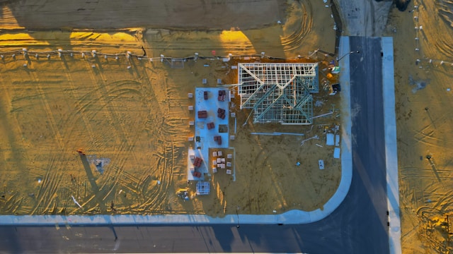
Site Plan in Architecture
A site plan is one of the most critical drawings in architecture—it translates design intent into a real-world context. Unlike isolated plans or elevations, a site plan captures how a building interacts with its surroundings, including access, landscape, topography, and existing conditions. For students and professionals alike, understanding site plan terminology is essential not just for reading drawings, but for making informed design decisions. Each element on a site plan carries functional, regulatory, and spatial implications, from circulation paths to property boundaries.
Site Plan Terminologies
Access
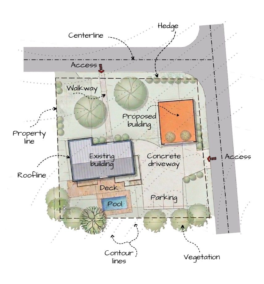
Access refers to the entry and exit points to a site, whether for pedestrians, vehicles, or service movement. It defines how users approach and navigate the property, making it a primary driver of circulation planning. In a site plan, access points must align with road networks, safety regulations, and ease of movement. Poorly planned access can lead to congestion, unsafe crossings, or inefficient layouts, while well-designed access enhances usability and spatial clarity.
Centerline
The centerline represents the midpoint of a road and is a crucial reference for setbacks, alignment, and infrastructure planning. It helps define how far a building or element must be placed from the road, based on local regulations. In site planning, the centerline ensures accurate positioning of driveways, access points, and site boundaries relative to public infrastructure.
Concrete Driveway
A concrete driveway indicates a designated vehicular path within the site, typically connecting access points to parking or garages. Its placement impacts circulation efficiency, turning radii, and pedestrian safety. The material specification also suggests durability and load-bearing capacity, making it a functional as well as a visual component of the site.
Contour Lines
Contour lines represent the topography of a site by connecting points of equal elevation. They are essential for understanding slope, drainage, and earthwork requirements. In a site plan, contour lines inform decisions about building placement, foundation design, and water flow. Closely spaced contours indicate steep slopes, while wider spacing suggests flatter terrain.
Deck
A deck is an elevated or semi-elevated outdoor platform, often attached to a building. In site plans, it extends usable living space into the outdoors and indicates transitions between interior and exterior zones. Its placement considers views, sunlight, and privacy, making it both a functional and experiential element.
Existing Building
An existing building represents any structure already present on the site before intervention. Documenting it accurately is crucial for renovation, extension, or demolition decisions. It establishes context, constraints, and opportunities, influencing how new design elements integrate with the built environment.
Hedge
Hedges are linear vegetation elements used as soft boundaries, privacy screens, or landscape features. On a site plan, they define edges without the rigidity of walls, contributing to both aesthetics and spatial zoning. Their placement often responds to privacy needs, wind direction, and visual screening.
Parking
Parking areas indicate designated spaces for vehicle storage, including layout, orientation, and circulation paths. In a site plan, parking must balance efficiency with accessibility, ensuring smooth movement while complying with regulations such as minimum dimensions and turning clearances. Its location also affects the overall user experience and visual quality of the site.
Pool
A pool is a recreational water feature that requires careful integration into the site due to safety, drainage, and maintenance considerations. Its placement typically responds to sunlight, privacy, and proximity to indoor spaces. In a site plan, it also influences surrounding landscaping and circulation.
Property Line
The property line defines the legal boundary of a site. It is one of the most critical elements in a site plan, as all construction must occur within or in relation to these limits. Setbacks, easements, and zoning regulations are measured from property lines, making them fundamental to compliance and design feasibility.
Proposed Building
The proposed building represents the new construction or intervention being planned. Its position on the site plan reflects design intent, considering factors such as orientation, access, setbacks, and environmental response. It acts as the central element around which all other site components are organized.
Roofline
The roofline outlines the edges of a building’s roof as seen in plan. It may differ from the building footprint due to overhangs, projections, or design features. In a site plan, the roofline helps understand shading, drainage, and the visual massing of the structure.
Vegetation
Vegetation includes trees, shrubs, and other plantings present or proposed on the site. It plays a key role in microclimate control, shading, and visual quality. In site plans, vegetation is carefully mapped to preserve existing greenery or introduce new landscaping strategies that enhance the environment.
Walkway
Walkways define pedestrian movement within the site, connecting entry points, buildings, and outdoor spaces. Their layout influences how users experience the site, guiding movement intuitively. In a site plan, walkways must balance directness with comfort, considering width, material, and accessibility.
This guide breaks down key site plan components, explaining what they represent and how they influence design outcomes.
Conclusion
Understanding site plan terminology goes beyond memorizing labels—it is about recognizing how each element contributes to a cohesive and functional design. From contour lines shaping the terrain to access points guiding movement, every component plays a role in defining how a site operates and feels. A well-read site plan allows architects to design with clarity, respond to context, and create spaces that are both efficient and meaningful.
These were some insights on Site Plan Terminologies. Stay tuned for more information on other significant topics in the AEC industry and follow Kaarwan for such detailed guides!
FAQs
1. What is the purpose of a site plan in architecture?
A site plan shows how a building interacts with its surroundings, including access, landscape, and existing conditions.
2. Why are contour lines important in a site plan?
They help understand terrain, slope, and drainage, which influence building placement and construction.
3. What is the difference between existing and proposed buildings?
Existing buildings are already present on site, while proposed buildings represent new design interventions.
4. How do property lines affect design?
They define legal boundaries and determine setbacks, buildable areas, and compliance with regulations.
5. Why is access planning important in site design?
It ensures smooth and safe movement for pedestrians and vehicles, improving usability and efficiency.