


Gone are the days when site visits meant trudging through mud and drawing sketches manually. In 2026, architecture students and young professionals have an unmatched toolkit at their disposal, including AI-powered drones, LiDAR sensors, advanced GIS mapping, intelligent BIM integration, and digital twins that reflect the physical world in real time. So, to put things in perspective, these are no longer futuristic add-ons; they are the foundation of contemporary site analysis, design strategy and professional credibility.
If the 2025 story was about adopting these technologies, the 2026 story will be about mastering the intelligence layer on top of them. Drones can now process data onboard in real time, and
GIS is now converging with BIM to create a seamless digital-physical ecosystem. Digital twins are now turning static models into living, breathing manifestations of a site that updates as the world evolves.
Let’s look into what’s new in 2026 and why it matters for your career. We’ll also explore how Kaarwan’s upskilling programs can help you get there!
_1750058787578.png)
Drone Surveys in 2026: From Aerial Eyes to Intelligent Data Machines
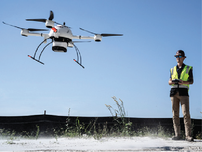
Today’s drones are not just cameras in the sky. In 2026, they are high-precision geospatial tools that are capable of delivering survey-grade data that meets or exceeds traditional ground-based methods, and AI is one of the main facilitators to make that analysis happen automatically.
What Drones Can Now Do for Architects
Photogrammetry & Digital Twins: Site mapping using photogrammetry creates digital twins that you can mesh directly into Revit or Rhino. While this remains the basis, in 2026, the outputs are richer and faster than ever.
LiDAR-equipped UAVs: LiDAR has become the go-to standard for survey-grade mapping. On one side, photogrammetry gives you images, and LiDAR gives you a dense millimetre-accurate point cloud (even in intense vegetation or complex structural environments). Costs have also dropped dramatically, making it accessible to architecture firms of all sizes.
Multispectral & Thermal Sensors: Modern drone payloads bring RGB cameras, LiDAR, multispectral and thermal sensors under the same roof, giving you data on surface geometry, vegetation health, thermal performance and material composition simultaneously.
Scan-to-BIM Workflows: Drone-captured point clouds are converted into accurate BIM models, representing real-world site conditions. This is impactful for renovation, retrofit and adaptive reuse projects where as-built documentation is crucial.
AI-powered Analytics: In 2026, AI models trained on large datasets can automatically classify drone data like flagging risks, detecting changes over time and feeding insights directly into BIM and GIS platforms without going through manual processing. Research also confirms that this reduces project documentation time by over 50%.
Drone-in-a-box Monitoring: Automated drone-in-a-box solutions now give 24/7 continuous site monitoring for prolonged construction projects. This will also help in capturing data autonomously throughout the building lifecycle.
Regulatory Context: BVLOS Is Opening Up
The initial 2025 observation that ‘regulatory frameworks are easing’ is now much more prevalent. In August 2025, the FAA released a landmark proposed rule (Part 108) for Beyond Visual Line of Sight (BVLOS) drone operations. When implemented, this will give architects and survey teams the leeway to conduct large-area site scans with minimal ground supervision—dramatically expanding what a single operator can achieve on a complex urban or rural site. Early BVLOS waivers, like the nationwide FAA waiver secured by DroneDeploy, are already making use of fully autonomous construction monitoring at scale.
What does this mean for you? This definitely means you’re not just scanning the site, you’re generating a data-rich, AI-processed, multi-layered digital record of it. You are now looking at a future spatial intelligence strategist self from day one, armed with data that traditional methods could never create.
GIS Mapping in 2026: The Language of Context-Aware Design
GIS is no longer used only by geographers and planners. In 2026, architects are not just using GIS, they are using it with BIM, drone data, AR/VR, and AI to develop multilayered narratives that justify every design choice with evidence.
What GIS Enables Today?
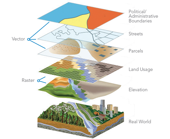
- Overlay population density, zones, transportation networks, flood risks and social infrastructure in order to understand how they interact to shape design constraints and opportunities.
- Combine drone imagery, UAV data, and CAD plans to develop rich base maps for site observation and evaluation. In 2026, this data will serve BIM environments without any manual re-entry.
- GIS will also let you run and visualise scenarios like how a new road, a 100-year flood event or climate change will impact your site. GIS will help you anticipate and mitigate these scenarios before a single brick is even laid.
- GIS and BIM are converging, and platforms that once operated in silos are now deeply interoperable. Esri’s ArcGIS and Autodesk’s BIM platforms share data natively, allowing geospatial intelligence to be added in building-level asset models. This is now transforming infrastructure, urban planning, and large-scale architectural projects.
- Using AR headsets, design teams and city officials can now walk through a GIS-linked virtual version of a proposed design that can come in handy in simulating factors like shadow patterns, wind tunnels and spatial relationships before the construction commences. The global AR/VR market in architecture and design is anticipated to reach $9.2 billion by 2027.
Real World Example: The Singapore Green Corridor Project utilised GIS-integrated rendering to visualise a 24km urban ecological network, optimising both design precision and stakeholder engagement. This is the kind of data storytelling that gets you clients, gets planning approvals and builds reputations.
What does this mean for you? This leads to a more context-aware designer whose proposals are backed up by verifiable spatial evidence. That’s not just good design, that’s actually winning trust with the clients, planning communities and authorities.
_1750058768887.png)
BIM in 2026: From Coordination Tool to Data Intelligence Ecosystem
Modern BIM workflows let you export drone and GIS data straight into Revit, creating base site models that are precise on day one. But in 2026, BIM has evolved far beyond this foundational capacity. The industry is now operating under what practitioners call BIM 6.0, which is a swift shift from a model-centric workflow to data-driven, AI-augmented ecosystems.
What BIM 6.0 Means in Practice
- AI-Automated Workflows: AI now automates repetitive BIM tasks, including clash detection, model validation, code compliance checking and quantity takeoffs. Around 27% of AEC firms globally are using AI in their design and construction development systems in 2026, with this adoption taking a sharp turn.
- IoT-Connected Models: BIM models in 2026 stay “live” through IoT sensor feeds, cloud updates and AI insights. Rather than becoming outdated after handover, they move on to becoming operational layers for facility management and lifecycle monitoring.
- Cloud-Based Common Data Environments (CDEs): Integrated cloud platforms now bring design, construction and facility management into one collaborative workflow. The US General Services Administration (GSA) has now implemented ‘Single Source of Truth’ BIM workflows for federal projects. This not only highlights the direction in which the industry is heading, but research also showcases how CDEs can reduce rework by 5-15%.
- GIS-BIM Integration: For metro systems, highways, utility networks, renewable energy zones and airports, GIS-BIM convergence builds a seamless bridge between real-world geospatial intelligence and building-level asset information. For large-scale architectural and urban projects, this is now the bare minimum expectation and not an advanced skill.
- Environmental Intelligence from Day One: BIM workflows to include environmental analysis like sun paths, wind, slope, and drainage, as an attempt to de-influence massing and orientation choices from early stages. In 2026, AI pushes this further with real-time energy simulation that can give near-instant feedback on design decisions that usually took weeks.
What does this mean for you? You’re not simply modelling, you’re building a living, data-rich digital asset that will form the next stage of your project’s life, right from concept to demolition.
Digital Twins: The Living Model That Changes Everything
What is a digital twin? To put it simply, it’s a real-time virtual replica of a physical place that was updated continuously by drone surveys, IoT sensors and AI analysis. In 2026, digital twins have transcended from experimental pilots to mainstream AEC tools.
Why Digital Twins Matter for Architecture Students?
- LiDAR drones conduct regular site sweeps to encapsulate spatial changes at millimetre accuracy, while IoT sensors embedded in buildings and infrastructure keep providing constant data. Together, they keep the digital twin in sync with the physical reality.
- Digital twins push design teams to compare design intent against the as-built environment at any given stage of construction, which is used in detecting discrepancies and resolving them in real time.
- The digital twin market is anticipated to grow from $16.75 billion in 2024 to $110.1 billion by 2029. Employers in smart city firms, urban planning consultancies and large-scale architectural practices are actively on the lookout for professionals who understand this technology.
- Generative Urban Design utilises digital twins as the computational substrate. This enables planners to input their specific parameters (500 units of affordable housing, 20% increase in green space) and AI runs multiple design permutations to find optimal layouts. This is the future of masterplanning.
For architecture students, understanding digital twins means understanding how infrastructure and cities that they are designing will be monitored, maintained and optimised long after they have handed over the keys. That’s not really a technical skill; it’s a professional responsibility.
Generative AI: Turning Site Data Into Design Options
Here is where 2026 becomes truly exciting for architects. The converging point of drone data, GIS analysis and BIM is now pitching into a new generation of AI-assisted generative design tools. This allows you to move from site survey to design exploration and development faster than ever before.
What This Looks Like in Practice
- Using ChatGPT-integrated Dynamo in Revit, architects can put in natural-language design prompts, and AI translates them into parametric scripts. This can then lead to generating an instant design iteration, keeping the site data in consideration.
- Vibe coding also involves natural language to create custom design logic and scripts. This is also 2026’s defining AI trend for architecture, according to leading AEC firms. Truth is, you don’t have to be a programmer; you need to be a precise communicator.
- AI-assisted real-time energy simulation now gives near-instant feedback on orientation, massing and environmental performance. This answers questions like ‘what is the optimal orientation of this building to increase daylight and decrease overall energy usage?’ in minutes.
- TestFit and Architectures use generative AI to develop live site feasibility studies, yield analysis and code-compliant layout options. This directly creates a GIS-informed site boundary.
What does this mean for you? Your role is shifting from ‘someone who draws’ to ‘someone who directs’, creating AI-generated options, making strategic judgments, and ensuring that design intelligence serves real human and environmental needs.
The 2026 Data-Driven Workflow in Action
Here is an updated, step-by-step analysis and design process that reflects current best practices in 2026:
Phase 1: Site acquisition
- Drone flight to collect high-resolution imagery, LiDAR point clouds, and multispectral data.
- GIS study helps overlay food zones, zoning, topography, transportation networks, vegetation and social infrastructure.
- AI classification of drone data comes with automated site condition assessment and change detection.
Phase 2: Modelling & Integration
- Import drone LiDAR data or information using Scan-to-BIM systems (point cloud to Revit via Civil 3D or Recap Pro).
- Add GIS data layers as context in your BIM environment, including factors like site topography, adjacency, and zoning as live layers.
- Use context-centric massing tools with AI-assisted placement and optimisation.
Phase 3: Environmental Analysis
- Run AI-accelerated sun/shadow and wind analysis utilising Revit plugins or Grasshopper scripts.
- Overlay accessibility, view corridors, noise zones and thermal performance data.
- Use real-time energy simulation to check massing and orientation decisions instantly (doesn’t take weeks or even days)
Phase 4: Generative Design Exploration
- Explore parametric design iterations using AI-assisted Dynamo or Grasshopper workflow systems
- Take site constraints, programme requirements, and sustainability targets into generative AI tools
- Validate options against code compliance, environmental performance, and structural feasibility automatically.
Phase 5: Synthesis & Communication
- Present integrated site plans, visualisations, and diagrams that showcase cultural, environmental and user activity or responsiveness.
- Generate a digital twin from your combined drone, GIS, and BIM model for client and stakeholder presentations.
- Use AR/VR tools to allow clients to “walk through” the design in its real-world GIS factors.
_1750058752283.png)
Skills You'll Need in 2026
The 2025 skill set remains basic, but 2026 is anticipating additional skills and expecting professionals to work through them.
2025 Skills (Still Essential)
- Drone piloting and photogrammetry
- GIS mapping — QGIS or ArcGIS
- Smart site modelling in Revit (BIM workflow)
- Climate simulation tools and plugins
- Data communication/transfer in maps and diagrams
New Skills for 2026
- LiDAR data processing- TerraScan, LAStools, LiDAR360 or PDAL for intense point cloud workflows.
- Scan-to-BIM - Converting reality-capture data into precise, coordinated BIM models.
- Digital twin literacy: Understanding how drone, GIS, and AI data come together to create and maintain living models.
- AI tools for architecture: Veras, TestFit, Archicad AI Visualiser, ChatGPT-integrated parametric workflows
- Vibe coding/prompt engineering for design development: Using natural language to direct AI design tools efficiently.
How You Can Learn It at Kaarwan
- Start with the Guide to Site Analysis Masterclass to catch drone mapping, GIS surveys, LiDAR basics and data layering, which is updated as per 2026 workflows.
- Add BIM for Civil Engineers or BIM for Architects to add drone and GIS data sets into real design platforms by utilising Revit, Civil 3D, and Scan-to-BIM systems.
- Explore digital twin and generative design workshops to break down living models and AI-assisted exploration, which are reiterating the entire profession.
- Use Revit-integrated plugins to understand and analyse light, wind, slope and embed site intelligence into early design phases, and now adding AI-assisted simulation tools.
A Mini Challenge: Build Your First Site Intelligence Kit
Head to a local park or public area:
- Take a short drone flight (wherever allowed) to freeze aerial imagery.
- Process the imagery by using a free AI-enabled photogrammetry tool (DroneDeploy, Pix4D, or OpenDroneMap) and let AI segregate and structure the output automatically.
- Use QGIS to locate tree paths, infrastructure overlays and flood risk layers.
- Create a Revit massing model using site data as the foundation, and try Scan-to-BIM if you want to use a point cloud.
- Ask an AI generative design tool to suggest three massing options to choose from, based on your site limitations.
- Collect everything into a simple digital twin, including site model, environmental data and design options in order to present it as a portfolio.
Final Reflection: The Architect as Data Intelligence Designer
Site analysis in 2026 is not about intuition anymore, or even about data alone. It’s about data + AI + empathy + strategic intelligence. Using drones, LiDAR, GIS, BIM, digital twins, and generative AI together doesn’t make your work cleaner; it rather makes it more meaningful, more futuristic and more defensible.
The architects and planners who will come forth as those who can move fluidly between the physical site and its digital mirror understand not just how to collect data, but how to direct AI in interpreting it, how to embed spatial intelligence into every design decision. This will also help professionals to communicate intelligence to clients, communities and contractors.
Kaarwan’s BIM courses and site analysis workshops will help you master this workflow and put you ahead. You’ll be the one who sees the site not just as a plain and simple plot of land, but as a living, data-rich ecosystem waiting to be grasped, respected and transformed.
FAQs
1. What do drones do in site analysis?
They capture accurate site data (images, LiDAR, thermal) and enable real-time, AI-driven analysis.
2. How is GIS useful for architects?
It helps analyse site context—zoning, environment, and infrastructure—for better design decisions.
3. What is BIM 6.0?
A data-driven BIM system that uses AI, IoT, and cloud tools to create live, evolving models.
4. What is a digital twin?
A real-time digital replica of a site or building that updates continuously with live data.
5. How is AI used in architecture?
AI automates tasks, analyzes data, and generates design options quickly.
6. What is Scan-to-BIM?
It converts real-world scan data into accurate BIM models.
7. What skills are needed in 2026?
BIM, GIS, LiDAR, AI tools, and data-driven design skills are essential.
8. How do drones, GIS, and BIM work together?
Drones collect data, GIS adds context, and BIM turns it into design models.
9. Are these tools accessible to beginners?
Yes, costs are lower and many tools have beginner-friendly versions.
10. Why is data-driven design important?
It improves accuracy, reduces risk, and supports better design decisions.




.png)