
What is Chain Surveying in Civil Engineering?
Chain surveying in civil engineering is one of the oldest and most straightforward methods of land measurement. At its core, it involves measuring only linear distances; no angular measurements are taken in the field. Instead, the survey area is divided into a network of triangles using chains or tapes, and all calculations and plotting are carried out later in the office.
The method is best suited for relatively flat, open areas where the terrain does not create significant obstacles and where a high degree of precision is not critical. Think of small plot surveys, boundary marking for residential properties, preliminary site assessments for road or canal works, or simple topographic mapping in agriculture; these are exactly the scenarios where chain surveying remains the most practical and cost-effective choice.
Despite the growth of total stations, GPS, and BIM-integrated survey tools in 2026, chain surveying continues to be taught as a foundational technique in civil engineering because it builds the spatial reasoning and measurement discipline that underpins all more advanced survey methods.
Read more: Surveying in Civil Engineering
Principles of Chain Surveying
The practice of chain surveying in civil engineering is governed by two core principles that guide every measurement taken in the field.
Working from the whole to the part. Before any detailed measurements are taken, the surveyor establishes a large framework of control points and survey lines that covers the entire area. Once this framework is in place, smaller details, the positions of buildings, fences, roads, and other features, are filled in relative to it. This approach ensures that errors remain localised and do not accumulate across the entire survey.
Locating a point using at least two reference measurements. The position of any new point is determined by measuring from two already known reference points. This is why chain surveying builds its framework from triangles; the triangle is the simplest geometric shape that can be uniquely defined by the lengths of its three sides alone, without needing any angle measurements. As long as the lengths of all three sides of a triangle are known, the triangle can be plotted accurately and without ambiguity.
In practice, this means the surveyor divides the survey area into a series of well-conditioned triangles, triangles where no angle is less than 30 degrees or greater than 120 degrees, and measures the sides of each triangle directly using the chain or tape. The resulting network of triangles forms the skeleton of the survey, onto which all the surrounding detail is mapped using offsets.
Read more: Compass Surveying
Types of Chain in Surveying
Understanding the types of chains in surveying is essential for choosing the right tool for a given project. Each type of chain has a specific length, number of links, and primary application.
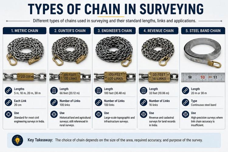
| Chain Type | Length | Number of Links | Primary Use |
| Metric Chain | 5 m, 10 m, 20 m, or 30 m | Varies (each link 20 cm) | Standard for most civil engineering surveys in India today |
| Gunter's Chain | 66 feet (20.12 m) | 100 links | Historical land and agricultural surveys; still referenced in rural surveys |
| Engineer's Chain | 100 feet (30.48 m) | 100 links | Large-scale topographic and infrastructure surveys |
| Revenue Chain | 33 feet (10.06 m) | 16 links | Revenue and cadastral surveys for land records in India |
| Steel Band Chain | 20 m or 30 m | Continuous steel band | High-precision surveys where link chain accuracy is insufficient |
The metric chain is the most widely used type of chain in surveying in India in 2026. It is available in standard lengths of 5, 10, 20, and 30 metres, with each link measuring 20 centimetres. Tallies , small brass markers , are provided at every 5 links to help the surveyor keep track of the distance covered. Swivel joints at both ends allow the chain to be folded and unfolded without twisting.
Gunter's Chain, named after the 17th-century mathematician Edmund Gunter, measures 66 feet and is divided into 100 links, each 0.66 feet long. Its historical significance lies in the convenient property that 10 square chains equals exactly one acre, making it extremely practical for agricultural land surveys. It is still referenced in rural surveying contexts and in regions where the imperial system of measurement was historically used.
Engineer's Chain measures 100 feet and is divided into 100 links of 1 foot each, making distance reading straightforward. It is used for large-scale surveys, topographic mapping, highway alignment surveys, and railway route planning, where the longer chain length speeds up measurement over extended areas.
Revenue Chain is shorter at 33 feet, divided into 16 links. It is specifically used for revenue and cadastral surveys in India, the measurement and recording of land parcels for government land records and property taxation purposes.
Steel Band Chain is a narrow steel band rather than a linked chain, with markings at every metre, decimetre, and centimetre. It provides continuous measurement without interruption at link joints, making it significantly more accurate than link chains for precision work. It is typically used where higher accuracy is required than a standard link chain can provide.
Chain Length in Surveying
The choice of chain length in surveying depends on the size of the area being surveyed, the required accuracy, and the terrain conditions.
For small plots and boundary surveys in India, residential properties, agricultural land, and small site layouts, a 20 metre metric chain is the standard choice. It is manageable for two-person survey teams and provides good accuracy for the scale of work involved.
For larger areas, road alignment, canal design, infrastructure site surveys, a 30 metre metric chain or an engineer's chain is more appropriate, as fewer chain lengths need to be laid out to cover the same distance, reducing cumulative measurement error and speeding up the fieldwork.
For very small, detail-intensive surveys, particularly in urban environments where plot sizes are compact and boundary measurements must be precise, a 10 metre chain or a steel tape is preferred.
As a general rule in chain surveying in civil engineering, the longer the chain, the faster the survey, but the greater the potential for cumulative error over multiple chain lengths. Shorter chains are more accurate per unit length but slower to use over large areas. Matching chain length to site scale is one of the key practical judgements a surveyor makes before fieldwork begins.
Still unsure about your civil engineering career path? Learn in-demand skills like BIM, GPS, and modern surveying tools with Kaarwan’s Civil Engineering course. Get job-ready with practical training—register now and start building your future.
Instruments Used in Chain Surveying
Chain surveying uses a straightforward set of instruments, each with a specific purpose in the measurement and recording process.
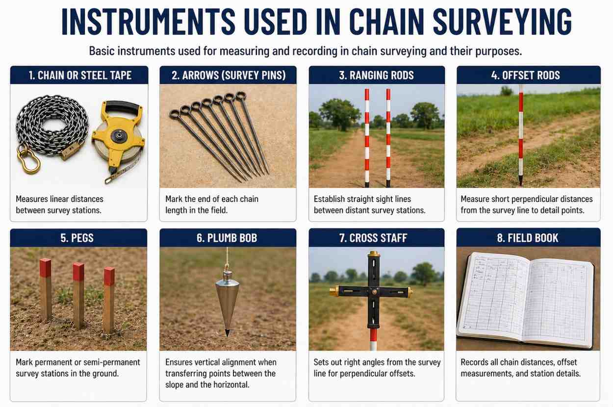
| Instrument | Purpose |
| Chain or Steel Tape | Measures linear distances between survey stations |
| Arrows (Survey Pins) | Mark the end of each chain length in the field |
| Ranging Rods | Establish straight sight lines between distant survey stations |
| Offset Rods | Measure short perpendicular distances from the survey line to detail points |
| Pegs | Mark permanent or semi-permanent survey stations in the ground |
| Plumb Bob | Ensures vertical alignment when transferring points between the slope and the horizontal |
| Cross Staff | Sets out right angles from the survey line for perpendicular offsets |
| Field Book | Records all chain distances, offset measurements, and station details |
A chain or steel tape is the primary measurement tool. Chains are robust and durable for fieldwork. Steel tapes are used where greater accuracy is needed or where the terrain makes chain laying difficult.
Arrows are thin, pointed iron rods inserted into the ground at the end of each chain length to mark the surveyor's progress along a long line. A standard set of ten arrows is used , the follower collects each one as the leader moves forward, and the count of arrows held by the follower indicates how many full chain lengths have been measured.
Ranging Rods are straight poles 2 to 3 metres tall, painted in alternating red and white bands of 200 mm for visibility. They are placed at survey stations and along the survey line to enable the surveyor to maintain a straight line of measurement over long distances.
Offset Rods are similar to ranging rods but shorter, used to measure short distances perpendicular to the main survey line, called offsets, to locate surrounding detail like building corners, fence lines, and road edges.
Pegs are wooden or metal stakes driven into the ground to mark survey stations and other important reference points. They provide stable, semi-permanent markers that remain in place throughout the survey.
A plumb bob is a weighted tool suspended on a string used to transfer a point directly below an elevated position, useful on sloping ground where the chain must be held horizontally and the endpoint transferred vertically to the ground.
A cross staff is an instrument with two pairs of sighting slots at right angles to each other, mounted on a pole. It allows the surveyor to sight along the main survey line and simultaneously set out a perpendicular direction for offset measurement.
Procedure of Chain Surveying
The chain surveying procedure follows a consistent sequence of steps that ensures the survey is systematic, accurate, and well-documented.
Step 1: Reconnaissance: Before any measurement begins, the surveyor walks the entire area to be surveyed. This preliminary inspection identifies suitable locations for survey stations, assesses the terrain for obstacles, and allows the surveyor to plan the network of triangles that will form the survey framework. A rough sketch, called a key plan or index sketch, is prepared showing the proposed layout.
Step 2: Marking Stations: The surveyor selects and marks the main survey stations at locations from which the maximum possible area is visible and from which straight survey lines can be run without obstruction. Stations are marked by driving pegs into the ground, painting marks on hard surfaces, or placing ranging rods. The number of stations should be the minimum necessary to cover the area in well-conditioned triangles.
Step 3: Running Survey Lines: Beginning from the baseline, the longest and most accurately measured line, which should pass approximately through the centre of the area, the surveyor chains each survey line in the network. Ranging rods are placed along each line to maintain straightness. The chain is laid out one length at a time, with arrows placed at each chain length, and the total distance is recorded in the field book.
Step 4: Taking Offsets: For each feature that needs to be located, building corners, fence lines, road edges, and trees, an offset measurement is taken. The surveyor identifies the point on the survey line closest to the feature (for a perpendicular offset) or takes oblique measurements from two known points on the line. The offset distance and the chainage point at which it was measured are both recorded in the field book.
Step 5: Booking Field Notes: All measurements are recorded in a standard field book. Chain distances are entered along the central column, and offset measurements are recorded on either side in the direction they were taken. Sketches of the surrounding features are added to make the records clear and unambiguous. The field book is the permanent record of all measurements and must be kept neat, complete, and legible.
Step 6: Checking: Check lines, lines that cross the triangles and connect known points, are measured and compared against their plotted lengths to verify the accuracy of the survey. If a checkline measurement differs significantly from the plotted length, an error exists in one or more of the triangle sides and must be identified and corrected before the survey is finalised.
Advantages and Disadvantages of Chain Surveying
Advantages of Chain Surveying
- Simple to learn and easy to execute without specialised training
- Requires no complex instruments
- Equipment is low-cost, durable, and easily available
- Suitable for small, flat, and open areas
- Provides acceptable accuracy for preliminary surveys and boundary work
- Useful for simple site layouts
- Relies only on linear measurements, so angular errors are eliminated
Disadvantages of Chain Surveying
- Not suitable for large areas due to cumulative measurement errors
- Accuracy reduces over long distances
- Difficult to use on steep slopes or uneven terrain
- Not practical in heavily vegetated or built-up areas
- Cannot measure angles, limiting its application in complex projects
- Not suitable for road curves or detailed structural layouts
- Largely replaced by modern methods like total stations and GPS (as of 2026)
- Mostly limited to small-scale and preliminary surveys today
Applications of Chain Surveying
Chain surveying in civil engineering finds practical application in several specific contexts where its simplicity and low cost are genuine advantages.
- It is used for small boundary surveys of residential plots and agricultural land, where the area is not too large and the ground is mostly flat
- Helpful for preliminary site surveys, giving a quick and low-cost idea of the site layout before detailed surveying is done
- Used in setting out simple structures and rural roads, especially in areas where advanced equipment like total stations or GPS is not available
- Suitable for mapping irrigation channels, drainage systems, and farm boundaries in agricultural projects where high precision is not required
- Useful in low-budget projects, as it requires minimal instruments and is easy to carry out
- Widely used in civil engineering education and training, helping students understand basic concepts like measurements, offsets, and field data recording
- Chain surveying is just the start. BIM-based surveying now uses GPS, GIS, and point cloud data integrated directly into 3D project models. Upgrade your skills with Kaarwan's BIM Certification Program for Civil Engineers
Still unsure about your civil engineering career path? Learn in-demand skills like BIM, GPS, and modern surveying tools with Kaarwan’s Civil Engineering course. Get job-ready with practical training—register now and start building your future.
Frequently Asked Questions
What is chain surveying in civil engineering?
Chain surveying in civil engineering is a basic land measurement method that uses a chain or tape to measure only linear distances in the field. The survey area is divided into a network of triangles, and all calculations and plotting are done in the office. It is best suited for small, flat, open areas where high precision is not critical.
What are the types of chains in surveying?
The main types of chains in surveying are the metric chain (available in 5, 10, 20, and 30 metre lengths), Gunter's chain (66 feet, 100 links), the engineer's chain (100 feet, 100 links), the revenue chain (33 feet, 16 links), and the steel band chain (20 or 30 metres of continuous steel). The metric chain is the standard in India today.
What instruments are used in chain surveying?
The main instruments used in chain surveying are the chain or steel tape for distance measurement, arrows for marking chain length endpoints, ranging rods for establishing straight sight lines, offset rods for perpendicular measurements to detail points, pegs for marking stations, a plumb bob for vertical transfer on slopes, and a cross staff for setting out right angles.
What is the standard chain length in surveying?
The standard chain length in surveying depends on the application. A 20 metre metric chain is the most commonly used for small- to medium civil engineering surveys in India. A 30 metre chain is preferred for larger areas. An engineer's chain of 100 feet is used for large-scale topographic and infrastructure surveys, and a steel band chain of 20 to 30 metres is used where greater accuracy is required.