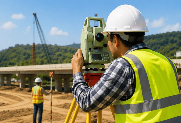
What is Surveying in Civil Engineering?
Surveying in civil engineering is the science and art of measuring and mapping the Earth's surface to determine the relative positions of points, distances between them, and differences in elevation. It provides the spatial data foundation that every construction project depends on , from the earliest site investigation through to final as-built documentation.
To define surveying in civil engineering more precisely: it is the process of acquiring accurate measurements of land, structures, and physical features to support the planning, design, and execution of infrastructure projects, including roads, bridges, buildings, dams, and drainage systems. The professionals who carry out this work are called surveyors, and they collaborate closely with civil engineers, structural engineers, architects, and urban planners to ensure that every project is built where it should be, at the right elevation, and within the correct boundaries.
The definition of surveying in civil engineering has evolved significantly with technology. What was once accomplished with chains, staffs, and magnetic compasses is now supported by GPS satellites, total stations, drones, laser scanners, and increasingly, Building Information Modelling platforms that integrate survey data directly into 3D project models.
Importance of Surveying in Civil Engineering
Understanding the importance of surveying in civil engineering helps explain why it is always the first activity that happens before any construction project begins , and why it continues throughout the project lifecycle.
It provides the spatial foundation for all design decisions: Every structural calculation, every road alignment, every drainage gradient is based on the spatial data that surveying provides. Without accurate survey data, even the most sophisticated structural design is built on unreliable assumptions.
It ensures construction aligns with design intent: Setting out , transferring the positions and levels from the design drawings to the physical ground , is a core surveying activity. It ensures that foundations, columns, road edges, and utility routes are positioned exactly where the design requires them to be.
It supports legal compliance and boundary definition: Surveying establishes property lines, ownership boundaries, and land use limits that are legally binding. Without accurate boundary surveys, construction projects risk encroachment disputes, planning violations, and legal liability.
It enables early identification of site challenges: Topographic surveys reveal slopes, water bodies, existing structures, underground utilities, and unstable terrain before construction begins. Identifying these conditions early avoids costly redesigns and site problems during construction.
It underpins cost control and quantity estimation : Volume calculations for earthwork , cut and fill , and quantity takeoffs for materials are derived from survey data. Inaccurate survey data leads to inaccurate estimates, which leads to budget overruns.
It supports infrastructure maintenance. Surveying does not stop at project completion. Regular condition surveys of roads, bridges, retaining walls, and buildings track deformation, settlement, and deterioration over time, enabling timely maintenance and preventing structural failures.
Objectives of Surveying in Civil Engineering
The objectives of surveying in civil engineering cover both data collection and practical application across the project lifecycle. Here are the core objectives:
• To determine the relative positions of points on, above, and below the Earth's surface with sufficient accuracy for the required engineering application.
• To measure horizontal distances, vertical elevations, and angles between points to establish a reliable spatial framework for the project.
• To prepare accurate maps, plans, and 3D models that represent the physical features of a site and form the basis for engineering design.
• To set out the positions and levels of proposed structures on the ground, transferring design information from drawings into physical markers for construction teams.
• To establish benchmarks and control points that provide a consistent reference framework for all measurements throughout the project.
• To determine land boundaries, legal property lines, and construction zones to ensure compliance with ownership rights and planning regulations.
• To calculate earthwork volumes (cut and fill) to support accurate cost estimation and construction planning.
• To monitor structural condition and deformation of existing infrastructure over time, aiding maintenance and safety assessment programs.
Upgrade your surveying skills with Kaarwan’s BIM Certification Program for Civil Engineers—learn how modern survey data integrates with BIM tools like Revit, Navisworks, Civil 3D, and Tekla.
Types of Surveying in Civil Engineering
Surveying in civil engineering is broadly divided into two fundamental types based on the extent of the area being surveyed and whether the curvature of the Earth is taken into account.
| Criteria | Plane Surveying | Geodetic Surveying |
| Earth's curvature | Ignored , Earth treated as flat | Accounted for in all calculations |
| Area coverage | Small areas typically under 250 km² | Large areas spanning hundreds of km² |
| Accuracy level | Moderate , sufficient for most building and infrastructure work | Very high , required for national mapping and large infrastructure networks |
| Instruments used | Chains, tapes, compasses, dumpy levels, theodolites | Total stations, GPS/GNSS receivers, precise levelling instruments |
| Typical applications | Building layout, road alignment, property boundary surveys, canal and drainage design | National highway networks, railway alignments, international boundaries, satellite positioning |
| Mathematical basis | Plane trigonometry | Spherical trigonometry and geodesy |
Plane Surveying is the most commonly used type for civil engineering projects in India. Since the Earth's curvature has negligible effect on distances under approximately 10 to 15 km, plane surveying is sufficient for the vast majority of building, road, bridge, and infrastructure work at a local or regional scale.
Geodetic Surveying is required when the project spans large distances where ignoring the Earth's curvature would introduce significant measurement errors. It forms the basis of national control networks, topographic mapping programmes, and large-scale infrastructure alignments. GPS-based surveying is essentially a form of geodetic surveying, using satellite signals referenced to the Earth's ellipsoidal shape.
Classification of Surveying in Civil Engineering
Beyond the plane versus geodetic division, the classification of surveying in civil engineering extends across several other parameters, each relevant to how a particular project or site condition is best approached.
Classification by Purpose
Engineering surveying covers all survey work undertaken in support of construction projects, including topographic surveys for design, setting out for construction, and as-built surveys for documentation and handover.
Cadastral surveying focuses on establishing and recording property boundaries and land ownership, and forms the legal basis for land registration and property transactions.
Topographic surveying maps the natural and man-made features of an area, such as contours, watercourses, vegetation, roads, and structures , to support planning and design decisions.
Hydrographic surveying is conducted in and around water bodies, rivers, lakes, harbours, and coastal areas to map underwater topography and support navigation, flood management, and coastal engineering.
Archaeological surveying uses precision measurement techniques to document historical sites, ruins, and artefacts, supporting heritage preservation and excavation planning.
Classification by Nature of the Area
Land surveying covers all work conducted on the Earth's surface, the most common form across civil engineering disciplines.
Underground surveying is performed in mines, tunnels, and underground structures to map and monitor geometry, alignment, and conditions.
Aerial surveying uses aircraft or drones to capture photographic and sensor data from above, enabling rapid mapping of large areas and difficult-to-access terrain.
Marine surveying encompasses work in or under water bodies, including bathymetric surveys of river and harbour beds and surveys of coastal and offshore infrastructure.
Upgrade your surveying skills with Kaarwan’s BIM Certification Program for Civil Engineers—learn how modern survey data integrates with BIM tools like Revit, Navisworks, Civil 3D, and Tekla.
Classification by Instrument Used
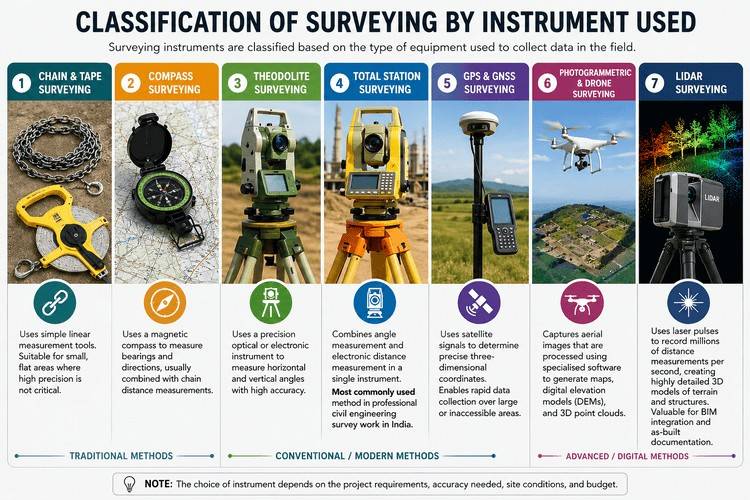
Chain and Tape Surveying: Uses simple linear measurement tools; suitable for small, flat areas where high precision is not required.
Compass Surveying: Employs a magnetic compass to measure bearings and directions, usually combined with chain distance measurements.
Theodolite Surveying: Uses a precision optical or electronic instrument to measure horizontal and vertical angles with high accuracy.
Total Station Surveying: Combines angle measurement and electronic distance measurement in a single instrument; widely used in professional civil engineering survey work in India.
GPS and GNSS Surveying: Utilises satellite signals to determine precise three-dimensional coordinates, enabling fast data collection over large or inaccessible areas.
Photogrammetric and Drone Surveying: Captures aerial images that are processed using specialised software to generate maps, digital elevation models (DEMs), and 3D point clouds.
LiDAR Surveying: Uses laser pulses to record millions of distance measurements per second, creating highly detailed 3D models of terrain and structures; especially valuable for BIM integration and as-built documentation.
Methods Used in Surveying
Each surveying method has specific strengths and is suited to particular site conditions, accuracy requirements, and project scales. This section gives a practical overview of the core methods:
Chain Surveying: Chain surveying is one of the oldest and simplest methods, using a measuring chain to determine linear distances between points on relatively flat, open ground. It works best for small areas where high precision is not critical and where the terrain allows direct measurement between stations.
Compass surveying: Compass surveying uses a magnetic compass to measure the bearings of survey lines, combined with chain or tape measurements for distances. It is suited to areas where a limited number of control points are available and where moderate accuracy is acceptable. The prismatic compass is the most commonly used instrument in India for this method.
Levelling: Levelling is the technique used to determine the difference in height between points on the Earth's surface. It is essential for establishing vertical control, the elevation datum from which all height measurements on a project are referenced, and for setting out structures at the correct level. A dumpy level or digital level is used with a levelling staff to measure height differences.
Tacheometric Surveying: Tacheometry is a rapid method of measuring distances and elevation differences using a theodolite or total station. It is particularly useful for surveys in rough or hilly terrain where chaining is impractical, allowing the surveyor to determine both the horizontal distance and the height difference to a remote point from a single instrument setup.
Plane Table Surveying: Plane table surveying is a graphical method where the survey map is drawn directly in the field as measurements are taken. The plane table, a drawing board mounted on a tripod, is oriented at each station, and the positions of surrounding points are plotted directly onto the map sheet using a sighting rule called an alidade. While largely replaced by digital methods, it remains a valuable technique for rapid topographic mapping in the field.
Upgrade your surveying skills with Kaarwan’s BIM Certification Program for Civil Engineers—learn how modern survey data integrates with BIM tools like Revit, Navisworks, Civil 3D, and Tekla.
Instruments Used in Surveying
The instruments used in surveying in civil engineering range from simple mechanical tools to sophisticated digital and satellite-based systems. The choice of instrument depends on the required accuracy, the area to be surveyed, and the project type.
Traditional instruments include the measuring chain and tape for distance, the magnetic compass for direction, the dumpy level and levelling staff for height differences, and the theodolite for precise angle measurement.
Modern instruments include the total station, which combines angle measurement and electronic distance measurement , GPS and GNSS receivers for satellite-based positioning, digital levels for automated height measurement, drones for aerial survey and mapping, and LiDAR scanners for high-density 3D point cloud capture.
In 2026, BIM-integrated survey workflows are becoming increasingly common on major infrastructure projects in India, where LiDAR and drone-captured point cloud data are imported directly into Revit or Civil 3D to create coordinated 3D models for design and construction.
Applications of Surveying in Civil Engineering
Surveying is used at every stage of a civil engineering project—from planning to construction and even maintenance.
Site Planning and Preparation: Topographic surveys map natural and man-made features, helping engineers plan foundations, drainage, earthwork, and overall site layout before design begins.
Road and Highway Alignment: Surveying helps fix the road path, levels, and cross-sections. It ensures the best route is chosen and supports setting out road edges, kerbs, and drainage.
Bridge and Structural Layout: Used to accurately set out foundations, piers, and structural elements. Even small errors at this stage can lead to major construction issues.
Property and Boundary Surveys: Defines legal land boundaries and construction zones, helping with land acquisition, approvals, and avoiding disputes.
Volume and Quantity Calculations: Survey data is used to calculate earthwork (cut and fill), which is essential for cost estimation and construction planning.
Infrastructure Monitoring: Regular surveys track movement or deformation in structures like bridges and buildings, helping detect problems early and ensure safety.
BIM and Digital Construction Integration: Modern surveying uses LiDAR and drones to create 3D models and point clouds, which are integrated into BIM for accurate design, renovation, and as-built documentation.
Modern surveying now uses BIM and GIS tools. Learn how in Kaarwan's BIM Civil Program →
If you are a civil engineering student or working professional looking to add digital construction skills to your surveying foundation, Kaarwan's BIM Certification Program for Civil Engineers covers how modern survey data integrates with BIM workflows, including point cloud processing in Revit, model coordination using Navisworks, and infrastructure modelling in Civil 3D and Tekla.
Frequently Asked Questions
What is surveying in civil engineering?
Surveying in civil engineering is the science and art of measuring and mapping the Earth's surface to determine the relative positions of points, distances, and elevations. It provides the spatial data foundation for planning, designing, and constructing infrastructure projects, including roads, bridges, buildings, and dams.
How do you define surveying in civil engineering?
The definition of surveying in civil engineering describes it as the systematic process of collecting, analysing, and representing spatial data about land, structures, and physical features to support engineering decision-making across all stages of a construction project , from site investigation and design through construction and maintenance.
What are the main objectives of surveying in civil engineering?
The main objectives of surveying in civil engineering include determining the positions and elevations of points, preparing accurate maps and plans, setting out the positions of proposed structures on the ground, establishing property boundaries, calculating earthwork volumes, and monitoring structural condition over time.
What is the classification of surveying in civil engineering?
The classification of surveying in civil engineering covers several dimensions. By type: plane surveying and geodetic surveying. By purpose: engineering, cadastral, topographic, hydrographic, and archaeological surveying. By nature of area: land, underground, aerial, and marine surveying. By instrument: chain, compass, theodolite, total station, GPS, and LiDAR-based methods.
What are the types of survey in civil engineering?
The two primary types of survey in civil engineering are plane surveying , which treats the Earth's surface as flat and is suitable for most local construction projects , and geodetic surveying , which accounts for the Earth's curvature and is required for large-scale national infrastructure, mapping programmes, and satellite-referenced positioning systems.