Important Terms Used in Site Analysis
Site analysis is the foundation of every successful architectural project. Before a single line is drawn, architects study the physical, environmental, cultural, and regulatory conditions of a site. Understanding these layers allows designers to respond sensitively to climate, human activity, landscape, and legal parameters. The following key terminologies represent the essential components of a thorough site analysis. Organised alphabetically, each term explains what it means, why it matters, and how it influences the design process.
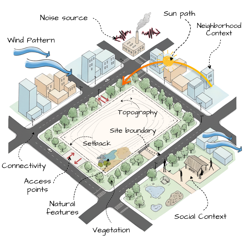
Image Credits: Shivani Chougula @Kaarwan
Access Points
Access points refer to all entry and exit locations that allow movement into, out of, or through a site. These include vehicular entries, pedestrian gates, service access, emergency access, and any existing pathways. Studying access points ensures safe circulation, efficient traffic flow, and clarity in zoning functional spaces. Good access planning also prevents conflicts between pedestrian and vehicular routes and influences where drop-offs, ramps, or entrances are placed.
Connectivity
Connectivity describes how well a site links to its larger urban or rural context—roads, public transport, walkability networks, bicycle paths, and important community nodes. High connectivity improves accessibility and sustainability and often increases site value. Analysing connectivity helps architects plan arrival sequences, position entrances, and design for inclusive mobility.
Natural Features
Natural features include rivers, water bodies, slopes, rock formations, contour variations, existing soil profiles, and any ecological systems present on or near the site. These elements influence design decisions like building placement, structural approach, flood protection, drainage patterns, and landscape integration. Preserving natural features often results in more sustainable and context-sensitive architecture.
Neighborhood Context
Neighborhood context refers to the built environment surrounding the site—building heights, architectural styles, street patterns, density, activities, and the overall character of the area. Understanding this context helps ensure that new development fits harmoniously within its surroundings, respects existing scale, and responds to the local identity. It also informs façade articulation, height control, and shading patterns caused by neighboring buildings.
Noise Source
Noise sources are points or zones that generate sound—roads, railways, industries, markets, construction zones, or even community gathering areas. Mapping noise levels helps architects orient quiet spaces away from high-noise edges, position sound buffers like landscape belts or walls, and select façade systems that improve acoustic comfort. This is crucial for residential, institutional, and healthcare projects.
Setback
Setbacks are mandatory minimum distances between the built structure and the site boundary, defined by development control regulations. They ensure ventilation, sunlight penetration, fire safety, and adequate separation between buildings. Understanding setbacks early helps establish buildable area, massing possibilities, and overall layout efficiency.
Site Boundary
The site boundary is the legal perimeter defining the exact extent of a plot. It is established using survey drawings, ownership records, and physical markers. Accurate knowledge of the boundary is essential for planning building footprint, fencing, zoning, infrastructure placement, and complying with regulations. Errors in understanding boundaries can lead to disputes or regulatory violations.
Social Context
Social context includes the cultural, behavioral, and community patterns surrounding the site—spaces where people gather, shared recreational areas, local traditions, and community activities. Analysing social context helps create architecture that responds to human behaviour, strengthens community interaction, and respects cultural identity. This influences public spaces, plaza design, and how buildings engage with the street.
Sun Path
Sun path analysis studies the movement of the sun across the site throughout the year. It helps architects optimise natural light, reduce heat gain, and strategically position windows, shading devices, courtyards, and open spaces. A clear understanding of solar exposure significantly improves energy efficiency and indoor comfort.
Topography
Topography describes the three-dimensional shape of the land—contours, slopes, gradients, and elevation differences. It affects drainage, structural design, accessibility, landscape planning, and the placement of buildings. Working with the natural topography rather than against it often reduces excavation, cost, and environmental disturbance.
Vegetation
Vegetation includes all existing trees, shrubs, ground cover, and ecological habitats on the site. Mapping vegetation helps identify elements worth preserving for shade, wind protection, ecological value, or aesthetic character. It also informs microclimate design, landscape zoning, and environmental impact mitigation.
Wind Pattern
Wind pattern analysis studies prevailing wind directions, seasonal variations, and micro-wind conditions influenced by surrounding structures and terrain. It helps architects design naturally ventilated buildings, place openings for optimal airflow, and shield against harsh winds. Wind data is essential for energy-efficient cooling strategies and outdoor comfort.
Final Thoughts:
Understanding site analysis terminology equips architects with a deeper awareness of the physical and contextual forces shaping a project. Each term plays a crucial role in informing design decisions—ensuring buildings are functional, climate-responsive, safe, contextually rooted, and environmentally responsible. A clear grasp of these fundamentals leads to architecture that not only fits its site but thrives because of it.
If you’d like to master these concepts hands-on, join Kaarwan’s online masterclass - Site Analysis & Climate Study, for structured, industry-relevant learning.