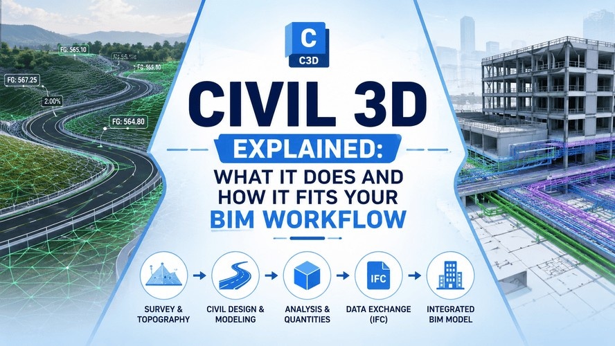
Here's the question that trips up almost every civil engineering student the first time someone mentions BIM software: "wait, isn't that just Revit?" No. And honestly, that confusion costs people weeks of misdirected learning. Revit is built for buildings, walls, floors, rooms, the stuff that sits still on a fixed site. Civil 3D is built for everything that moves across land, roads, pipelines, terrain that isn't flat and cooperative. If you're heading into civil or infrastructure BIM work, Civil 3D isn't optional knowledge. It's basically the tool.
What Civil 3D Does
Let's get the Revit-vs-Civil 3D thing sorted properly, because it really is the most common beginner question in this space, and getting it wrong early sets you up for a confusing few months.
Revit works brilliantly for vertical construction, buildings, where the site is basically a fixed backdrop and the real complexity lives in the structure itself. Civil 3D flips that. It's built specifically for horizontal infrastructure, roads, highways, rail corridors, land development, drainage networks, where the terrain itself is the primary design challenge. You're not designing walls, you're designing how water moves across a site, how a road climbs a hillside, how a pipe network avoids clashing with existing utilities buried underground.
Civil 3D uses a dynamic, model-based environment that plugs directly into BIM workflows, meaning it's not just drawing lines anymore, it's building an intelligent model where every surface, alignment, and corridor carries real data behind it. Change the design intent, the model updates. That's the whole point, and it's a genuinely different way of thinking than traditional 2D civil drafting ever was.
If your work touches land development, transportation design, water systems, or rail, Civil 3D is where that work actually happens. It's not a nice-to-have skill anymore, in most Indian infrastructure firms hiring for BIM roles, it's assumed you already know it.
Also Explore : MEP Drawing Types: A Complete Construction Guide
Core Civil 3D Workflows
Four things make up most of the daily-use feature set, and getting comfortable with these covers a huge chunk of real-world Civil 3D work.
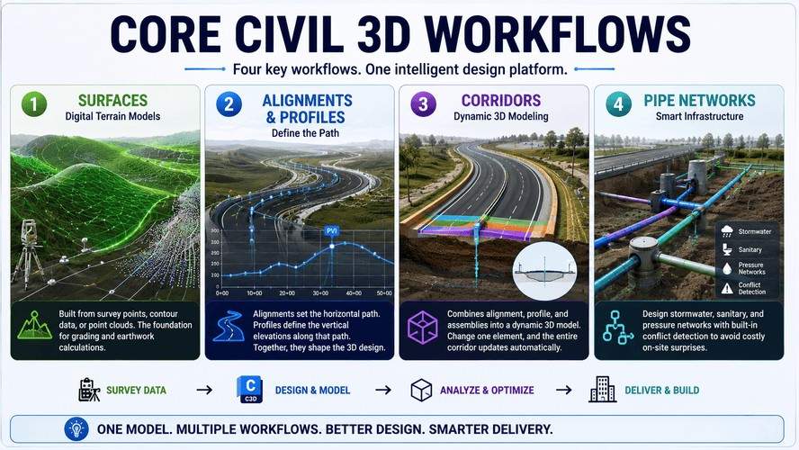
Surfaces are your digital terrain models (TIN surfaces), built from survey points, contour data, or point cloud imports. Every grading decision, every earthwork calculation starts here. Get your surface wrong, and everything downstream inherits that error.
Alignments define the horizontal path of a road, rail line, or pipeline, essentially the centerline the entire design wraps around. Pair that with profiles, which handle the vertical dimension, elevation changes along that same path, and you've got the full 3D geometry of a corridor's path defined before a single cross-section gets drawn.
Corridors are where it gets genuinely powerful. A corridor model ties your alignment, profile, and a cross-sectional "assembly" (think: lane widths, curb details, shoulder slopes) together into one dynamic 3D model. Adjust the alignment, and the entire corridor, every cross-section along its length, updates automatically. This is the feature that makes Civil 3D feel like real BIM rather than glorified 2D drafting.
Pipe networks round things out, letting you lay out stormwater, sanitary, and pressure networks with built-in conflict detection, catching clashes with existing utilities before they become an expensive surprise on-site.
Each of these workflows genuinely deserves its own deep dive, this page is meant to give you the map, not walk every mile. We'll be covering surface creation, alignment design, corridor assemblies, and drainage networks in dedicated guides soon.
Also Read : BIM Execution Plan Guide: Roles, Templates and Key Requirements
Civil 3D in a BIM Pipeline
Here's where a lot of students get stuck: Civil 3D doesn't work alone. On a real infrastructure project, it's one piece of a bigger coordinated pipeline, and understanding how it talks to other tools matters just as much as knowing the software itself.
The typical flow looks something like this. Early-stage planning and conceptual design often happens in InfraWorks, where you're working with GIS data, existing conditions, and rough massing before committing to detailed design. Once the project moves into detailed civil design, that's Civil 3D's territory, surfaces, alignments, corridors, the real engineering.
For projects with a structural or architectural component (bridges, buildings within a larger site), Civil 3D models connect into Revit, letting structural engineers reference accurate civil geometry rather than guessing at site conditions. And for coordination across disciplines, catching clashes between civil, structural, and MEP models, everything typically federates in Navisworks, where the whole team can review a combined model and flag conflicts before construction starts.
The connective tissue across all of this is the IFC format, an open standard that lets Civil 3D talk to software outside the Autodesk ecosystem too, not just within it. If you want to understand how that interoperability actually works at a technical level, that's covered properly under IFC as an interoperability standard, so no need to duplicate it here.
Point cloud data from site surveys also feeds directly into this pipeline, if you're working with laser scan or drone survey data, that raw data becomes usable terrain the moment it's processed into point cloud data into Civil 3D terrain surfaces. Worth understanding early, since so much real-world civil work starts with existing-conditions capture rather than a blank canvas.
Want to actually build these Civil 3D workflows instead of just reading about them? Kaarwan's Civil BIM Certification covers surfaces, corridors, and coordination the way real infrastructure teams work.
Also Read: BIM Standards Every Civil Engineer Should Know
Civil 3D vs InfraWorks — When to Use Which
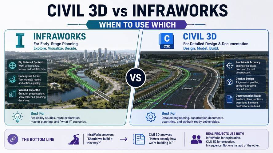
Quick version, because this one genuinely confuses people who've only heard both names thrown around together. InfraWorks is for the early, exploratory stage, conceptual design, planning-level decisions, testing multiple route or site options quickly against real GIS and terrain context. It's fast and visual, but not built for construction-level precision.
Civil 3D is for detailed design, once you've settled on a direction and need engineering-grade accuracy, actual alignments, actual grading, actual documentation that a contractor can build from. Think of InfraWorks as the "should we build it this way" tool, and Civil 3D as the "here's exactly how we're building it" tool. Most real projects use both, in sequence, not one instead of the other.
Getting Started — First Steps for Beginners
If you're opening Civil 3D for the first time, here's the honest, practical on-ramp, not the full feature list, just what actually gets you moving.
Start by importing survey data, points, point clouds, or existing CAD linework, and use it to build your first surface. This single step teaches you more about how Civil 3D thinks than any amount of reading interface tutorials. Once you've got a surface, try creating a basic alignment along it, even something simple like a straight road centerline. Add a profile. Watch how the software ties elevation to that path.
Don't rush toward corridors and complex assemblies before this foundation feels comfortable. It's tempting to want to build something impressive right away, but corridor work built on a shaky understanding of surfaces and alignments just creates confusing errors you won't know how to fix. For the full surface-creation workflow in proper depth, we've got a dedicated guide coming that walks through this step by step.
Also Read : Top 10 BIM Software for Civil Engineers
Common Beginner Mistakes
A few patterns show up constantly with people new to Civil 3D, worth knowing before you hit them yourself.
Broken surface boundaries. If your TIN surface has gaps or incorrect boundary definitions, every downstream calculation, volumes, contours, grading, inherits that error silently. Always double-check boundary conditions before trusting a surface for real work.
Misaligned coordinate systems. Working across survey data, GIS imports, and CAD files that don't share a consistent coordinate system is one of the fastest ways to end up with a project that looks fine in isolation but doesn't line up with anything else. Set your coordinate system correctly at the very start of a project, not halfway through.
Over-complicating corridor assemblies before understanding targets. Corridor assemblies can get genuinely complex, lane widths, superelevation, multiple subassemblies, but jumping into that complexity before you understand how targets (the alignments and surfaces a corridor references) actually work leads to corridors that behave unpredictably. Build simple first. Complexity later, once the fundamentals are solid.
Also Read: BIM Engineer Skills and Tools: Complete Guide 2026
Ready to move from watching tutorials to actually running Civil 3D on real projects? Kaarwan's Civil BIM track builds surface, alignment, and corridor skills employers are hiring for right now.
Conclusion
Civil 3D isn't really about learning another piece of software, it's about learning to think in terrain, alignments, and dynamic corridors instead of static 2D lines. Once that shift happens, the tool stops feeling intimidating and starts feeling like exactly what civil BIM work is supposed to be. Ready to get hands-on? Explore Kaarwan's Civil BIM Certification and start building these workflows for real.
FAQs
Is Civil 3D hard to learn?
It has a learning curve, mainly around understanding how surfaces, alignments, and corridors relate to each other, but it's genuinely more approachable than people expect once the core logic clicks. Most beginners get comfortable with basic workflows within a few weeks of consistent practice.
Is it required for government infrastructure projects in India?
BIM adoption is increasingly expected on larger government infrastructure tenders in India, and Civil 3D is the dominant tool firms use to deliver that. It's not universally mandated by law on every project, but it's fast becoming the practical standard for anyone doing serious infrastructure work.
How does it work with Revit?
Civil 3D handles the site and infrastructure geometry, while Revit handles buildings and structures. On projects where both exist, a bridge over a Civil 3D-designed road, for instance, the two models connect so structural teams can reference accurate civil geometry rather than working from disconnected assumptions.
Is there Civil 3D training available in India?
Yes, Kaarwan's Civil BIM Certification track covers Civil 3D alongside broader civil BIM workflows, built specifically around what Indian infrastructure firms are hiring for.