.jpeg)
The civil engineering industry is evolving rapidly. Today, technology plays a central role in how projects are planned, designed, and executed. One of the most impactful developments in recent years is BIM-GIS integration. Today, BIM in civil engineering is becoming a standard approach for delivering smarter and more efficient infrastructure solutions.
By combining Building Information Modelling (BIM) with Geographic Information Systems (GIS), civil engineers can design projects with a deeper understanding of real-world conditions. Instead of working with isolated models, engineers can visualise how infrastructure fits within its actual environment before construction begins. In fact, BIM for infrastructure projects is now widely adopted for highways, bridges, metro systems, and large urban developments.
For professionals and students, learning how these two technologies work together is becoming increasingly important in modern infrastructure design.
Understanding BIM and GIS
To understand their integration, it is important to first look at each technology separately.
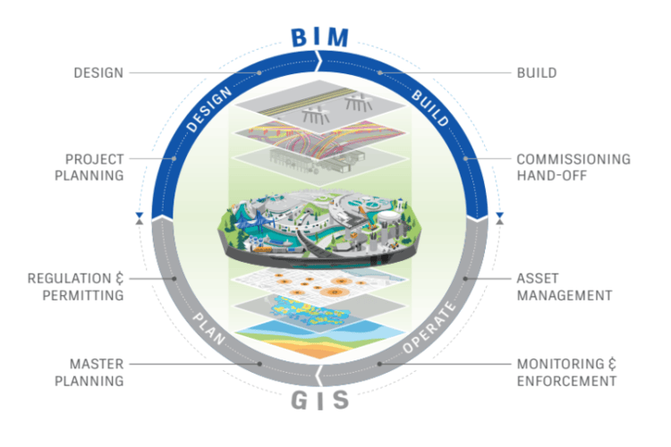
Image credit: harmony-at.com
Building Information Modelling (BIM) is a digital process used to create intelligent 3D models of buildings and infrastructure. These models are more than visual representations. They contain detailed data about materials, dimensions, costs, timelines, and maintenance. BIM improves coordination and supports better decision-making throughout a project’s lifecycle. This shift toward infrastructure BIM is helping civil engineers move from traditional 2D drafting to intelligent, data-driven modelling.
Geographic Information Systems (GIS) focus on spatial data. GIS collects, manages, and analyses geographic information such as terrain, roads, utilities, soil conditions, flood zones, and environmental factors. The growing adoption of GIS in civil engineering has strengthened the ability to design projects based on accurate site intelligence. It helps engineers understand the broader location context of a project.
When BIM and GIS are integrated, design data and geographic information are connected into a unified system. This creates a more complete and accurate project environment.
Why BIM-GIS Integration Matters
BIM-GIS integration strengthens visibility, collaboration, and data-driven decision-making across infrastructure projects.
Enhanced Project Visualisation
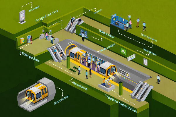
Image credits: Desapex
One of the biggest advantages of BIM-GIS integration is improved visualisation. Engineers can place detailed 3D BIM models directly onto real geographic maps. For example, a highway or metro station design can be viewed within its surrounding roads, utilities, terrain, and nearby structures.
This improves communication with clients, authorities, and stakeholders. When everyone can clearly see how a project interacts with its surroundings, approvals become smoother, and misunderstandings are reduced.
Improved Collaboration
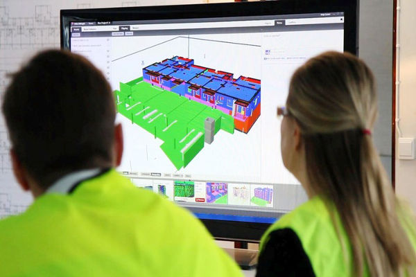
Image credits: BFT International
Large infrastructure projects involve multiple teams, including designers, planners, surveyors, and consultants. When teams work separately, coordination issues can arise.
With integrated BIM and GIS systems, teams can access shared data on a single platform. Thanks to cloud computing, project information can be updated and accessed in real time from different locations. This ensures better coordination, reduces duplication of work, and keeps everyone aligned.
Smarter Decision-Making Through Spatial Analysis
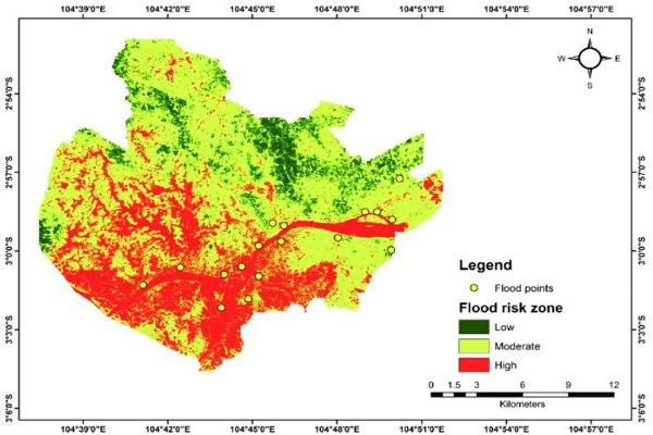
Image credits: ResearchGate
The real strength of integration lies in combining building data with spatial analysis.
Engineers can evaluate important questions during the design phase:
- Is the project located in a flood-prone area?
- Are there underground utilities that may interfere with foundations?
- How will terrain conditions affect road alignment?
- What is the most efficient route for material transportation?
Instead of solving problems during construction, engineers can identify risks early and make informed decisions during planning. This clearly demonstrates the key benefits of BIM-GIS integration in improving early-stage planning and reducing project risks.
Key Benefits for Civil Engineers
Modern infrastructure project planning using BIM allows engineers to evaluate technical, environmental, and logistical factors simultaneously.
Real-World Clash Detection
Traditional BIM detects clashes between structural and MEP systems. However, GIS-integrated BIM goes further by detecting conflicts between the design and real-world conditions.
Engineers can identify:
- Encroachments into restricted environmental zones
- Conflicts with underground utilities
- Height restrictions near airports
- Flood risk areas
By identifying these issues before construction begins, project delays and costly rework can be avoided.
Optimised Resource Planning
GIS data helps engineers evaluate transportation routes, supplier proximity, and site accessibility.
For example, traffic data can support better scheduling of material deliveries. Terrain data can assist in equipment planning. These advancements reflect the broader digital transformation in civil engineering, where data-driven tools improve efficiency, reduce costs, and enhance execution.
Better Infrastructure Planning
Infrastructure projects require environmental assessments, zoning compliance, and social impact studies.
With BIM-GIS integration, these considerations can be incorporated directly into the design workflow. Engineers can evaluate floodplain maps, land-use data, and utility networks while actively designing. This integrated approach supports smart infrastructure design strategies for rapidly growing urban environments. This results in more sustainable and well-planned infrastructure.
Advance Your BIM Skills with Professional Training
Want to build strong, real-world expertise in BIM workflows for civil and infrastructure projects? The Professional BIM Certification Program for Civil Engineers is designed to help you develop practical modelling, coordination, and documentation skills while gaining industry-relevant knowledge from fundamentals to advanced applications.
Conclusion
BIM-GIS integration is transforming how civil engineers plan, design, and manage infrastructure projects such as roads, bridges, highways, and urban developments. By combining detailed BIM data with geographic intelligence, civil professionals can improve visualisation, minimise site risks, optimise coordination, and make data-driven decisions throughout the project lifecycle.
To build strong expertise in this evolving field, civil engineers should invest in structured learning, such as the Professional BIM Certification Program for Civil Engineers. As infrastructure projects grow more complex and technology-driven, professionals who master BIM and understand its integration with GIS will be better equipped to lead modern infrastructure development with confidence and efficiency.
FAQs
1. What is the difference between BIM and GIS?
BIM focuses on detailed 3D building design and project data. GIS focuses on mapping and analyzing geographic and site data. BIM designs the structure; GIS understands the location.
2. Why is BIM-GIS integration important?
It helps engineers design projects with full site awareness, reducing risks, improving decisions, and avoiding costly mistakes.
3. Do I need to learn both BIM and GIS?
You don’t need to master both, but knowing how they work together gives you a strong career advantage.
4. What software is used for BIM-GIS integration?
Common tools include Autodesk Civil 3D, ArcGIS, Bentley OpenCities, and FME.
5. Is BIM-GIS only for large projects?
No. It’s useful for highways and metros, but also for residential, urban, and municipal projects.
6. How does it support sustainability?
It helps engineers consider flood zones, soil, and environmental data early — leading to smarter, eco-friendly designs.
7. Can BIM-GIS reduce costs?
Yes. It reduces design errors, rework, delays, and improves coordination — saving time and money.
8. What is a Digital Twin?
A Digital Twin is a virtual model of a real asset that combines BIM data, GIS location data, and live monitoring information.
9. Is it useful for smart cities?
Yes. Smart cities use BIM-GIS to plan transport, utilities, and urban growth efficiently.
10. How can students start learning?
Start with BIM tools (like Civil 3D or Revit) or GIS tools (like ArcGIS or QGIS). Hands-on practice is key.